Geolocate

Oslo topographic map

Click on the map to display elevation.

About this map

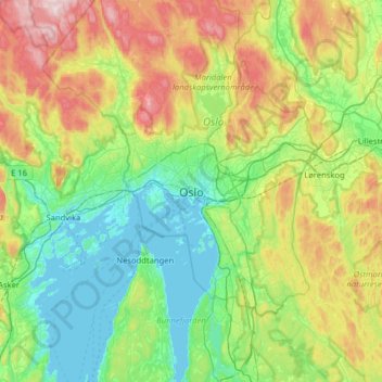
Name: Oslo topographic map, elevation, terrain.

Location: Oslo, 0026, Norway (59.75333 10.57897 60.07333 10.89897)

Average elevation: 186 m

Minimum elevation: -1 m

Maximum elevation: 638 m

Gear up for your next adventure:

🛠️Outdoor Repair Kits - Gear repair kits
📡Weather Radios - Emergency weather radios
🔦Powerful LED Headlamps - Hands-free lighting for night navigation and setting up camp after dark
📕Hiking Guide Books - Guides for hiking trails
🥤Outdoor Water Bottles - Reusable bottles for outdoor activities

As an Amazon Associate, this site earns from qualifying purchases at no extra cost to you.