
Bangka-Belitung Islands topographic map
Interactive map
Click on the map to display elevation.
Bangka-Belitung Islands
Bangka Belitung is entirely surrounded by water. It is bordered by Natuna Sea to the north, Karimata Strait to the east, Java Sea to the south and Bangka Strait to the west. The natural state of Bangka Belitung province is largely a plateau, valley and a small portion of the mountains and hills. Lowland altitude average of about 50 metres (160 ft) above sea level and altitude mountain areas among others to Mount Maras reach 699 metres (2,293 ft) in Belinyu District, Bangka. Mount Tajam Kaki height is approximately 500 metres (1,600 ft) above sea level on the island of Belitung. As for the hilly areas like Bukit Menumbing reaches a height of approximately 445 metres (1,460 ft) in the Bukit Nenas and Mangkol district with a height of about 395 metres (1,296 ft) above sea level in the Pangkalan Baru district. Soil in Bangka Belitung generally has a pH or acidic soil reaction averaging below 5, but has a very high aluminium content. Within it are various minerals, such as tin, sand, quartz sand, granite, kaolin, clay, and others.
About this map
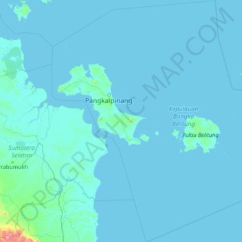
Name: Bangka-Belitung Islands topographic map, elevation, terrain.
Location: Bangka-Belitung Islands, Sumatra, Indonesia (-4.99936 104.99961 -0.27328 109.38979)
Average elevation: 14 m
Minimum elevation: -2 m
Maximum elevation: 2,123 m
Other topographic maps
Click on a map to view its topography, its elevation and its terrain.
Tembagapura
Indonesia > Central Papua > Mimika
Tembagapura is situated on a rocky plain at an altitude of 1,930 metres (6,330 ft) at the base of Mount Zaagkam, which lies 16 kilometres (9.9 mi) southeast of the mine. The town is in the Sudirman Range, not far from Puncak Jaya (Mount Carstens), the highest peak in Oceania. The area gets about 3,220…
Average elevation: 2,488 m