
Make a donation
Gear up for your next adventure:
As an Amazon Associate, this site earns from qualifying purchases at no extra cost to you.
Eixample topographic map
Click on the map to display elevation.
Make a donation
Gear up for your next adventure:
As an Amazon Associate, this site earns from qualifying purchases at no extra cost to you.
About this map
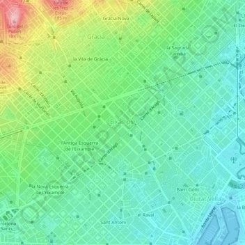
Name: Eixample topographic map, elevation, terrain.
Location: Eixample, Barcelona, Barcelonès, Barcelona, Catalonia, Spain (41.37491 2.14204 41.41203 2.18678)
Average elevation: 50 m
Minimum elevation: -1 m
Maximum elevation: 172 m
Make a donation
Gear up for your next adventure:
As an Amazon Associate, this site earns from qualifying purchases at no extra cost to you.
Other topographic maps
Click on a map to view its topography, its elevation and its terrain.
Make a donation
Gear up for your next adventure:
As an Amazon Associate, this site earns from qualifying purchases at no extra cost to you.
Parc dels Auditoris - El Parc del Fòrum
Spain > Catalonia > Barcelonès > Barcelona
Average elevation: 4 m
Make a donation
Gear up for your next adventure:
As an Amazon Associate, this site earns from qualifying purchases at no extra cost to you.