Geolocate

Sherenden topographic map

Interactive map

Click on the map to display elevation.

About this map

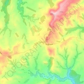
Name: Sherenden topographic map, elevation, terrain.

Location: Sherenden, Hastings District, Hawke's Bay, New Zealand (-39.52477 176.55512 -39.48477 176.59512)

Average elevation: 258 m

Minimum elevation: 129 m

Maximum elevation: 390 m

Other topographic maps

Click on a map to view its topography, its elevation and its terrain.

Hastings

New Zealand > Hawke's Bay > Hastings District

Hastings, Hastings District, Hawke's Bay, 4122, New Zealand

Average elevation: 68 m

Te Awanga

New Zealand > Hawke's Bay > Hastings District

Te Awanga, Hastings District, Hawke's Bay, 4180, New Zealand

Average elevation: 22 m

Cape Kidnappers / Te Kauwae-a-Māui

New Zealand > Hawke's Bay > Hastings District

Cape Kidnappers / Te Kauwae-a-Māui, Hastings District, Hawke's Bay, New Zealand

Average elevation: 16 m

Pakipaki

New Zealand > Hawke's Bay > Hastings District > Hastings

Pakipaki, Hastings, Hastings District, Hawke's Bay, 4178, New Zealand

Average elevation: 61 m