
Handwara topographic map
Interactive map
Click on the map to display elevation.
About this map
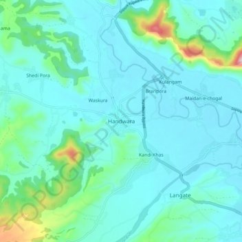
Name: Handwara topographic map, elevation, terrain.
Location: Handwara, Kupwara District, Jammu and Kashmir, 193221, India (34.35931 74.24274 34.43931 74.32274)
Average elevation: 1,638 m
Minimum elevation: 1,586 m
Maximum elevation: 1,931 m
Handwara is located at 34°24′N 74°17′E / 34.40°N 74.28°E / 34.40; 74.28 at an average elevation of 1,582 metres (5,190 feet) above sea level.
Other topographic maps
Click on a map to view its topography, its elevation and its terrain.
Gulgam
India > Jammu and Kashmir > Handwara > Gulgam
Gulgam, Handwara, Kupwara District, Jammu and Kashmir, India
Average elevation: 1,803 m