
Bleret topographic map
Interactive map
Click on the map to display elevation.
About this map
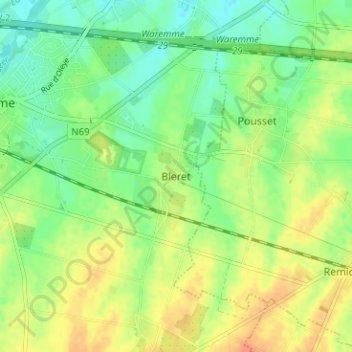
Name: Bleret topographic map, elevation, terrain.
Location: Bleret, Borgworm, Luik, Wallonië, 4300, België (50.66933 5.26889 50.70933 5.30889)
Average elevation: 126 m
Minimum elevation: 108 m
Maximum elevation: 147 m
Other topographic maps
Click on a map to view its topography, its elevation and its terrain.
Grand-Axhe
België > Luik > Borgworm > Borgworm
Grand-Axhe, Borgworm, Luik, Wallonië, 4300, België
Average elevation: 127 m
Bovenistier
België > Luik > Borgworm > Borgworm
Bovenistier, Borgworm, Luik, Wallonië, 4300, België
Average elevation: 139 m