
Moulinery topographic map
Interactive map
Click on the map to display elevation.
About this map
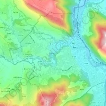
Name: Moulinery topographic map, elevation, terrain.
Average elevation: 494 m
Minimum elevation: 366 m
Maximum elevation: 766 m
Other topographic maps
Click on a map to view its topography, its elevation and its terrain.
Hameau de Berdoulet
France > Occitanie > Ariège > Foix
Hameau de Berdoulet, Foix, Ariège, Occitanie, France métropolitaine, 09000, France
Average elevation: 478 m
Les Bignes
France > Occitanie > Ariège > Foix
Les Bignes, Foix, Ariège, Occitanie, France métropolitaine, 09000, France
Average elevation: 574 m