Geolocate

Village of Walden topographic map

Interactive map

Click on the map to display elevation.

About this map

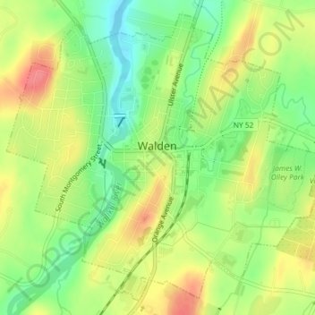
Name: Village of Walden topographic map, elevation, terrain.

Location: Village of Walden, Town of Montgomery, Orange County, New York, 12586, United States (41.54778 -74.20590 41.57260 -74.16959)

Average elevation: 114 m

Minimum elevation: 80 m

Maximum elevation: 149 m

The Wallkill passes through a small gorge between the two dams and loses approximately 60 feet (18 m) of elevation in the process. The surrounding topography in the village is, correspondingly, gentle rolling hills of this section of the Great Appalachian Valley between the higher rises of the Shawangunk Ridge, visible to the west from some sections of the village, and the Hudson Highlands to the southwest. The highest elevation is roughly 520 feet (160 m) above sea level along Overlook Road at the village's western boundary; the lowest is 260 feet (79 m) along the Wallkill at the northern village line.

Wikipedia (CC-BY-SA 3.0)

Other topographic maps

Click on a map to view its topography, its elevation and its terrain.

Cuddebackville

United States > New York > Orange County

Cuddebackville, Town of Deerpark, Orange County, New York, 12729, United States

Average elevation: 216 m

Town of Monroe

United States > New York > Orange County

Town of Monroe, Orange County, New York, United States

Average elevation: 229 m

Hawks Nest

United States > New York > Orange County

Hawks Nest, Town of Deerpark, Orange County, New York, 18340, United States

Average elevation: 230 m

Village of Monroe

United States > New York > Orange County

Village of Monroe, Town of Monroe, Orange County, New York, 10950, United States

Average elevation: 217 m

Village of Tuxedo Park

United States > New York > Orange County > Town of Tuxedo

Village of Tuxedo Park, Town of Tuxedo, Orange County, New York, 10987, United States

Average elevation: 230 m