
Astrakhan District topographic map
Interactive map
Click on the map to display elevation.
About this map
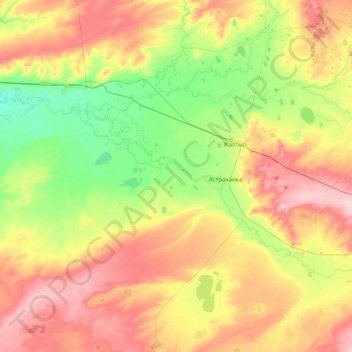
Name: Astrakhan District topographic map, elevation, terrain.
Location: Astrakhan District, Akmola Region, Kazakhstan (51.03471 68.92461 52.03475 70.44459)
Average elevation: 323 m
Minimum elevation: 273 m
Maximum elevation: 408 m
Other topographic maps
Click on a map to view its topography, its elevation and its terrain.
Qorğaljın
Kazakhstan > Akmola Region > Qorğaljın district
The village is located on the Kazakh Uplands. The average altitude in the village is about 330 meters above sea level. The terrain is a continuous plain with small hills and water areas.
Average elevation: 330 m