Geolocate

Chengdu topographic map

Click on the map to display elevation.

Chengdu

The vast plain on which Chengdu is located has an elevation ranging from 450 to 720 metres (1,480 to 2,360 feet).

About this map

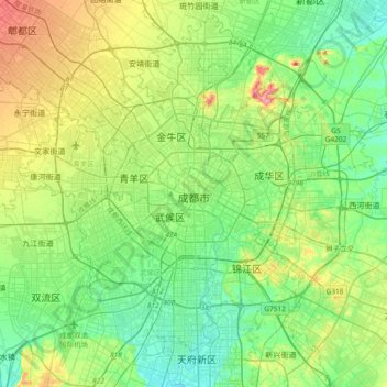
Name: Chengdu topographic map, elevation, terrain.

Location: Chengdu, Qingyang District, Chengdu City, Sichuan, 610015, China (30.50242 103.90332 30.82242 104.22332)

Average elevation: 505 m

Minimum elevation: 469 m

Maximum elevation: 590 m

Other topographic maps

Click on a map to view its topography, its elevation and its terrain.

Jinjiang District

China > Sichuan > Chengdu

Average elevation: 498 m

Gear up for your next adventure:

🌬️Windbreaker Jackets - Wind protection jackets
🔪Outdoor Multi-tools - Versatile tools for gear repair and survival tasks in the wilderness
🧦Merino Wool Hiking Socks - Moisture-wicking socks to prevent blisters during long topographic surveys
🧊Insulated Cooler Bags - Keep food fresh for day trips to remote geographic sites
🔪Multitools - Compact tools for outdoor use

As an Amazon Associate, this site earns from qualifying purchases at no extra cost to you.