
Make a donation
Gear up for your next adventure:
As an Amazon Associate, this site earns from qualifying purchases at no extra cost to you.
Boyacá topographic map
Click on the map to display elevation.
Make a donation
Gear up for your next adventure:
As an Amazon Associate, this site earns from qualifying purchases at no extra cost to you.
Boyacá
The department of Boyacá covers a small portion of the Middle Magdalena valley of the Magdalena River to the west, the Cordillera Oriental mountain range with altitudes of 5,380 m above sea level (Sierra Nevada del Cocuy with 25 snow peaks), flat highland plateaux, and another small portion of territory by the eastern Llanos plains. Among its most prominent geographical features are the Range of the Zorro, Serrania de las Quinchas and the Andean plateaus of Rusia, Guantivá, Pisba, Chontales and Rechiniga.
Make a donation
Gear up for your next adventure:
As an Amazon Associate, this site earns from qualifying purchases at no extra cost to you.
About this map
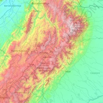
Name: Boyacá topographic map, elevation, terrain.
Location: Boyacá, RAP (Especial) Central, Colombia (4.65581 -74.65933 7.05484 -71.94333)
Average elevation: 1,402 m
Minimum elevation: 62 m
Maximum elevation: 5,125 m
Make a donation
Gear up for your next adventure:
As an Amazon Associate, this site earns from qualifying purchases at no extra cost to you.
Other topographic maps
Click on a map to view its topography, its elevation and its terrain.