
Zwijndrecht topographic map
Interactive map
Click on the map to display elevation.
About this map
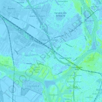
Name: Zwijndrecht topographic map, elevation, terrain.
Location: Zwijndrecht, Zuid-Holland, Nederland (51.80076 4.56674 51.84028 4.67171)
Average elevation: 1 m
Minimum elevation: -6 m
Maximum elevation: 14 m
Other topographic maps
Click on a map to view its topography, its elevation and its terrain.
Kleine-Lindt
Nederland > Zuid-Holland > Zwijndrecht > Heerjansdam
Kleine-Lindt, Heerjansdam, Zwijndrecht, Zuid-Holland, Nederland, 2995 XA, Nederland
Average elevation: 0 m
Heerjansdam
Nederland > Zuid-Holland > Zwijndrecht
Heerjansdam, Zwijndrecht, Zuid-Holland, Nederland
Average elevation: 0 m
Oude Maas
Nederland > Zuid-Holland > Zwijndrecht
Oude Maas, Zwijndrecht, Zuid-Holland, Nederland, 3311CD, Nederland
Average elevation: 3 m