
Lichterfeld topographic map
Interactive map
Click on the map to display elevation.
About this map
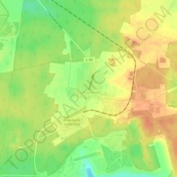
Name: Lichterfeld topographic map, elevation, terrain.
Average elevation: 129 m
Minimum elevation: 105 m
Maximum elevation: 145 m
Other topographic maps
Click on a map to view its topography, its elevation and its terrain.
Bergheider See
Deutschland > Brandenburg > Elbe-Elster > Lichterfeld-Schacksdorf > Lichterfeld
Bergheider See, Lichterfeld, Lichterfeld-Schacksdorf, Kleine Elster (Niederlausitz), Elbe-Elster, Brandenburg, Deutschland
Average elevation: 116 m