
Darkhan topographic map
Interactive map
Click on the map to display elevation.
About this map
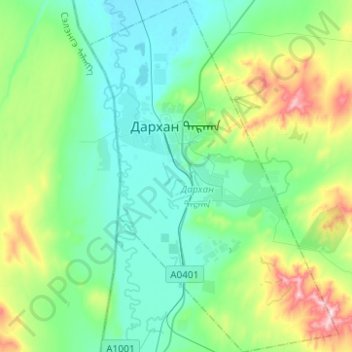
Name: Darkhan topographic map, elevation, terrain.
Location: Darkhan, Darchan-Uul, Mongolei (49.38809 105.87491 49.54931 106.05117)
Average elevation: 766 m
Minimum elevation: 672 m
Maximum elevation: 1,076 m
76 % der Bevölkerung des Aimag leben in der Stadt, die meisten davon in Plattenbauten, der Rest in Jurtensiedlungen. Der Anteil der russischstämmigen Einwohner ist höher als in anderen Städten der Mongolei.
Other topographic maps
Click on a map to view its topography, its elevation and its terrain.
Darchan
Mongolei > Darchan-Uul > Darchan
Darchan, Darkhan, Darchan-Uul, Mongolei
Average elevation: 723 m