
Make a donation
Gear up for your next adventure:
As an Amazon Associate, this site earns from qualifying purchases at no extra cost to you.
Navalagunda topographic map
Click on the map to display elevation.
Make a donation
Gear up for your next adventure:
As an Amazon Associate, this site earns from qualifying purchases at no extra cost to you.
Navalagunda
Navalgund is located at 15°34′N 75°22′E / 15.57°N 75.37°E / 15.57; 75.37. It has an average elevation of 578 metres (1896 feet). It is situated 35 km from Hubli and is famous as the birth place of 'Jamkhanas', the floor covering woven using cotton ropes, a kind of flat & thin carpet. Locally known as a Twin town with Naragund and together they are know as Bhandayad Nadu (Land of Rebels). It is famous for the Holi festival. The world famous Ramling Kamanna, to which people visit from various places during Holi Purnima. The famous Ajath Naglinga Swamy temple is in Navalgundas and well as the famous Nilamma Tank .
Make a donation
Gear up for your next adventure:
As an Amazon Associate, this site earns from qualifying purchases at no extra cost to you.
About this map
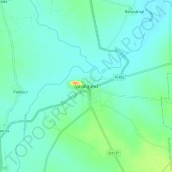
Name: Navalagunda topographic map, elevation, terrain.
Average elevation: 579 m
Minimum elevation: 564 m
Maximum elevation: 644 m
Make a donation
Gear up for your next adventure:
As an Amazon Associate, this site earns from qualifying purchases at no extra cost to you.