
Saint-Martial topographic map
Interactive map
Click on the map to display elevation.
About this map
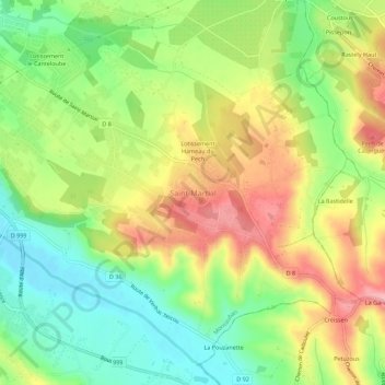
Name: Saint-Martial topographic map, elevation, terrain.
Average elevation: 147 m
Minimum elevation: 88 m
Maximum elevation: 216 m
Other topographic maps
Click on a map to view its topography, its elevation and its terrain.
Île de la Pissotte
France > Occitanie > Tarn-et-Garonne > Montauban
Île de la Pissotte, Villenouvelle, Villebourbon, Montauban, Tarn-et-Garonne, Occitanie, France métropolitaine, 82000, France
Average elevation: 95 m