
Fontao topographic map
Interactive map
Click on the map to display elevation.
About this map
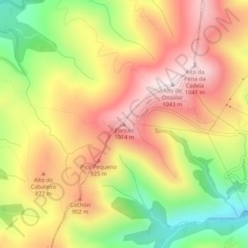
Name: Fontao topographic map, elevation, terrain.
Location: Fontao, O Valadouro, Mariña Central, Lugo, Galicia, España (43.49301 -7.56136 43.49311 -7.56126)
Average elevation: 806 m
Minimum elevation: 529 m
Maximum elevation: 1,034 m
Other topographic maps
Click on a map to view its topography, its elevation and its terrain.
Fazouro
España > Galicia > Mariña Central
Fazouro, Foz, Mariña Central, Lugo, Galicia, 27789, España
Average elevation: 105 m
Mondoñedo
España > Galicia > Mariña Central
Mondoñedo, Mariña Central, Lugo, Galicia, España
Average elevation: 356 m
Pedrouzo
España > Galicia > Mariña Central > Alfoz
Pedrouzo, Alfoz, Mariña Central, Lugo, Galicia, 27776, España
Average elevation: 408 m
A Granda
España > Galicia > Mariña Central > Alfoz
A Granda, San Pedro de Mor, Alfoz, Mariña Central, Lugo, Galicia, 27773, España
Average elevation: 71 m
Monte de San Pedro
España > Galicia > Mariña Central > Alfoz > Presa Boa
Monte de San Pedro, Presa Boa, Adelán, Alfoz, Mariña Central, Lugo, Galicia, España
Average elevation: 221 m
Alfoz
España > Galicia > Mariña Central > Alfoz
Alfoz, Mariña Central, Lugo, Galicia, España
Average elevation: 298 m
Andamil
España > Galicia > Mariña Central > O Valadouro > Andamil
Andamil, O Cadramón, O Valadouro, Mariña Central, Lugo, Galicia, España
Average elevation: 610 m
Foz
España > Galicia > Mariña Central
Foz, Mariña Central, Lugo, Galicia, 27780, España
Average elevation: 43 m
Lourenzá
España > Galicia > Mariña Central > Lourenzá
Lourenzá, Mariña Central, Lugo, Galicia, España
Average elevation: 260 m