
Make a donation
Gear up for your next adventure:
As an Amazon Associate, this site earns from qualifying purchases at no extra cost to you.
Unteriglbach topographic map
Click on the map to display elevation.
Make a donation
Gear up for your next adventure:
As an Amazon Associate, this site earns from qualifying purchases at no extra cost to you.
Unteriglbach
Wie alle auf -bach endenden Orte bezeichnet auch der Name Iglbach zunächst ein Gewässer, an dem die Siedlung liegt. Die „-bach“-Orte gelten als Zeugen frühen Eindringens ins Waldland. In der Topographie Baierns von Philipp Apian, welche um das Jahr 1580 in lateinischer Sprache entstand, wird das Dorf Ober-Eglbach mit Kirche aufgeführt. Weiter heißt es – supra hunc rivus ritur – oberhalb davon entspringt ein Bach. Es ist der Iglbach. Unter-Eglbach ist bei Apian ohne weiteren Zusatz genannt. Die Schreibung mit dem E-Laut findet sich sonst in keiner Quelle. Apian mag an eine Ableitung von Egel, wie Blutegel, oder von Igel gedacht haben. Wahrscheinlicher ist wohl die Ableitung von einem Personennamen. Ähnlich wie Aldersbach, Aidenbach und Beutelsbach ist wohl auch Iglbach mit einem Personennamen gebildet. Aldaro oder Altheri, Eito, Putilo. Bei Iglbach dürfen wir an die Koseform Iglo von der Kurzform Igo denken. Beide Formen sind in den Altdeutschen Namenbüchern von Förstemann und Kaufmann als beliebte und daher verbreitete Namensformen verzeichnet.
Make a donation
Gear up for your next adventure:
As an Amazon Associate, this site earns from qualifying purchases at no extra cost to you.
About this map
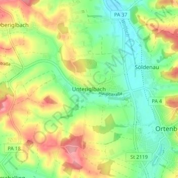
Name: Unteriglbach topographic map, elevation, terrain.
Average elevation: 373 m
Minimum elevation: 332 m
Maximum elevation: 428 m
Make a donation
Gear up for your next adventure:
As an Amazon Associate, this site earns from qualifying purchases at no extra cost to you.
Other topographic maps
Click on a map to view its topography, its elevation and its terrain.
Schloss Ortenburg
Deutschland > Bayern > Landkreis Passau > Ortenburg > Söldenau > Vorderschloß
Average elevation: 387 m