
Make a donation
Gear up for your next adventure:
As an Amazon Associate, this site earns from qualifying purchases at no extra cost to you.
Dunkirk topographic map
Click on the map to display elevation.
Make a donation
Gear up for your next adventure:
As an Amazon Associate, this site earns from qualifying purchases at no extra cost to you.
About this map
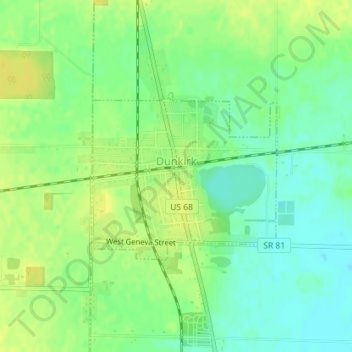
Name: Dunkirk topographic map, elevation, terrain.
Average elevation: 287 m
Minimum elevation: 276 m
Maximum elevation: 297 m
Make a donation
Gear up for your next adventure:
As an Amazon Associate, this site earns from qualifying purchases at no extra cost to you.
Other topographic maps
Click on a map to view its topography, its elevation and its terrain.
Roundhead
United States > Ohio > Hardin County
Located at an altitude of 1,004 feet (306 m), it sits at the intersection of State Routes 117, 235, and 385, 2.75 miles (4.43 km) north of the northeast corner of Indian Lake and 13 miles (21 km) southwest of the city of Kenton, the county seat of Hardin County. Despite Roundhead's proximity to Indian Lake and…
Average elevation: 311 m
Make a donation
Gear up for your next adventure:
As an Amazon Associate, this site earns from qualifying purchases at no extra cost to you.
Make a donation
Gear up for your next adventure:
As an Amazon Associate, this site earns from qualifying purchases at no extra cost to you.
Make a donation
Gear up for your next adventure:
As an Amazon Associate, this site earns from qualifying purchases at no extra cost to you.
Make a donation
Gear up for your next adventure:
As an Amazon Associate, this site earns from qualifying purchases at no extra cost to you.