
Lachal topographic map
Interactive map
Click on the map to display elevation.
About this map
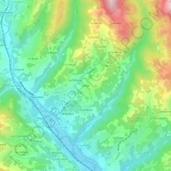
Name: Lachal topographic map, elevation, terrain.
Average elevation: 402 m
Minimum elevation: 271 m
Maximum elevation: 678 m
Other topographic maps
Click on a map to view its topography, its elevation and its terrain.
Le Philippe
France > Auvergne-Rhône-Alpes > Rhône > Létra
Le Philippe, Létra, Villefranche-sur-Saône, Rhône, Circonscription départementale du Rhône, Auvergne-Rhône-Alpes, France métropolitaine, 69620, France
Average elevation: 400 m