
Make a donation
Gear up for your next adventure:
As an Amazon Associate, this site earns from qualifying purchases at no extra cost to you.
Barnesville topographic map
Click on the map to display elevation.
Make a donation
Gear up for your next adventure:
As an Amazon Associate, this site earns from qualifying purchases at no extra cost to you.
About this map
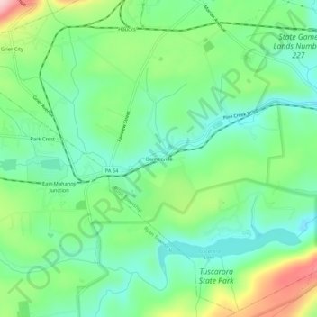
Name: Barnesville topographic map, elevation, terrain.
Average elevation: 358 m
Minimum elevation: 292 m
Maximum elevation: 500 m
Make a donation
Gear up for your next adventure:
As an Amazon Associate, this site earns from qualifying purchases at no extra cost to you.
Other topographic maps
Click on a map to view its topography, its elevation and its terrain.
Hometown
United States > Pennsylvania > Schuylkill County > Rush Township > Hometown
According to the United States Census Bureau, the CDP has a total area of 2.0 square miles (5.2 km2), all land. Hometown is located 2 miles (3.2 km) north of Tamaqua and 10 miles (16 km) south of Hazleton at the intersections of Route 54 and 309. Hometown's elevation is 1,129 feet (344 m) above sea level. It…
Average elevation: 352 m