
Thank you for supporting this site ❤️
Make a donation
Make a donation
Gear up for your next adventure:
As an Amazon Associate, this site earns from qualifying purchases at no extra cost to you.
Grundy topographic map
Click on the map to display elevation.
Thank you for supporting this site ❤️
Make a donation
Make a donation
Gear up for your next adventure:
As an Amazon Associate, this site earns from qualifying purchases at no extra cost to you.
About this map
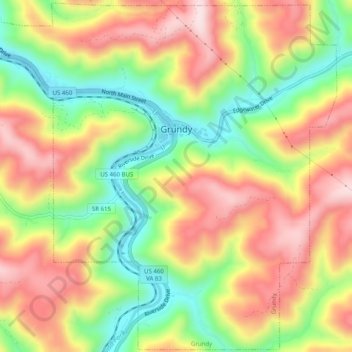
Name: Grundy topographic map, elevation, terrain.
Location: Grundy, Buchanan County, Virginia, 24614, United States (37.25350 -82.12691 37.29259 -82.07707)
Average elevation: 490 m
Minimum elevation: 310 m
Maximum elevation: 663 m
Thank you for supporting this site ❤️
Make a donation
Make a donation
Gear up for your next adventure:
As an Amazon Associate, this site earns from qualifying purchases at no extra cost to you.
Other topographic maps
Click on a map to view its topography, its elevation and its terrain.
Thank you for supporting this site ❤️
Make a donation
Make a donation
Gear up for your next adventure:
🐍Australian Snake Bite Kits - Specific pressure immobilization bandages for Australian venomous snakes
As an Amazon Associate, this site earns from qualifying purchases at no extra cost to you.