
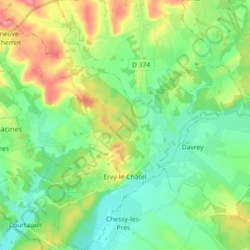
Ervy-le-Châtel topographic map
Interactive map
Click on the map to display elevation.
About this map
Name: Ervy-le-Châtel topographic map, elevation, terrain.
Average elevation: 139 m
Minimum elevation: 111 m
Maximum elevation: 195 m
Le village central se trouve à 161 mètres d'altitude, sur une colline au pied de laquelle coule la rivière Armance.
Other topographic maps
Click on a map to view its topography, its elevation and its terrain.
Les Croisettes
France > Grand Est > Aube > Dienville
Les Croisettes, Dienville, Bar-sur-Aube, Aube, Grand Est, France métropolitaine, 10500, France
Average elevation: 136 m
Clairvaux
France > Grand Est > Aube > Ville-sous-la-Ferté
Clairvaux, Ville-sous-la-Ferté, Bar-sur-Aube, Aube, Grand Est, France métropolitaine, 10310, France
Average elevation: 238 m
Bas du Village
France > Grand Est > Aube > Le Chêne
Bas du Village, Le Chêne, Troyes, Aube, Grand Est, France métropolitaine, 10700, France
Average elevation: 98 m
Saint-Nicolas-la-Chapelle
France > Grand Est > Aube > Saint-Nicolas-la-Chapelle
Saint-Nicolas-la-Chapelle, Nogent-sur-Seine, Aube, Grand Est, France métropolitaine, 10400, France
Average elevation: 91 m