
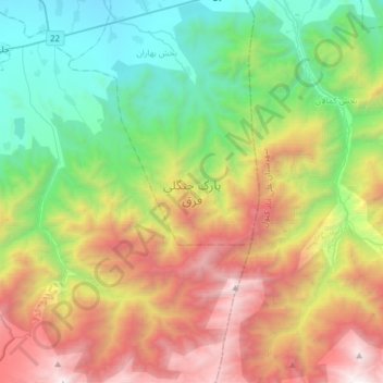
پارک جنگلی قرق topographic map
Interactive map
Click on the map to display elevation.
About this map
Name: پارک جنگلی قرق topographic map, elevation, terrain.
Location: پارک جنگلی قرق, Gorgan County, Golestan Province, Iran (36.63791 54.56772 36.88597 54.81553)
Average elevation: 1,247 m
Minimum elevation: 64 m
Maximum elevation: 3,243 m
Other topographic maps
Click on a map to view its topography, its elevation and its terrain.
Gorgan
Iran > Golestan Province > Gorgan County
Gorgan, بخش مرکزی, Gorgan County, Golestan Province, Iran
Average elevation: 180 m