
Huaca Blanca topographic map
Interactive map
Click on the map to display elevation.
About this map
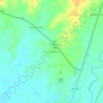
Name: Huaca Blanca topographic map, elevation, terrain.
Location: Huaca Blanca, Tambo Grande, Piura, Perú (-4.92613 -80.36725 -4.88613 -80.32725)
Average elevation: 72 m
Minimum elevation: 61 m
Maximum elevation: 94 m
Other topographic maps
Click on a map to view its topography, its elevation and its terrain.
Parque Sinchi Roca
Perú > Piura > Tambo Grande > Sinchi Roca
Parque Sinchi Roca, Atahualpa, Sinchi Roca, Tambo Grande, Piura, Perú
Average elevation: 85 m
Jesus Maria
Perú > Piura > Tambo Grande
Jesus Maria, Tambo Grande, Piura, Perú
Average elevation: 125 m