
Make a donation
Gear up for your next adventure:
As an Amazon Associate, this site earns from qualifying purchases at no extra cost to you.
Central Equatoria topographic map
Click on the map to display elevation.
Make a donation
Gear up for your next adventure:
As an Amazon Associate, this site earns from qualifying purchases at no extra cost to you.
About this map
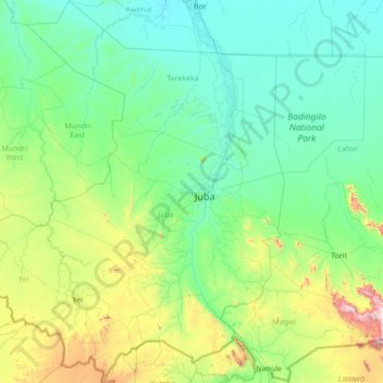
Name: Central Equatoria topographic map, elevation, terrain.
Location: Central Equatoria, South Sudan (3.48898 29.79678 6.25106 32.17315)
Average elevation: 647 m
Minimum elevation: 422 m
Maximum elevation: 2,417 m
Make a donation
Gear up for your next adventure:
As an Amazon Associate, this site earns from qualifying purchases at no extra cost to you.
Other topographic maps
Click on a map to view its topography, its elevation and its terrain.
Make a donation
Gear up for your next adventure:
As an Amazon Associate, this site earns from qualifying purchases at no extra cost to you.
Make a donation
Gear up for your next adventure:
As an Amazon Associate, this site earns from qualifying purchases at no extra cost to you.
Make a donation
Gear up for your next adventure:
As an Amazon Associate, this site earns from qualifying purchases at no extra cost to you.
Aweil
South Sudan > Northern Bahr el Ghazal > Aweil West
The topography is flat and prone to flooding. However, at an elevation of 425 m (1,394 ft) Aweil is on higher ground than the surrounding plains. The city lies close to the confluence of the Lol River with the Pongo River. The average elevation of the city of Aweil is about 425 metres (1,394 ft) above sea…
Average elevation: 431 m
Make a donation
Gear up for your next adventure:
As an Amazon Associate, this site earns from qualifying purchases at no extra cost to you.
Mount Kinyeti
South Sudan > Eastern Equatoria > Ikotos
Mount Kinyeti is the highest peak in South Sudan. It is located in the Imatong Mountains in Ikotos County of Eastern Equatoria, near the Ugandan border. Kinyeti has an elevation of 3,187 metres (10,456 ft) above sea level. The group of high mountains that contain Kinyeti, extending to the border with Uganda,…
Average elevation: 2,869 m
Make a donation
Gear up for your next adventure:
As an Amazon Associate, this site earns from qualifying purchases at no extra cost to you.
Make a donation
Gear up for your next adventure:
As an Amazon Associate, this site earns from qualifying purchases at no extra cost to you.
Make a donation
Gear up for your next adventure:
As an Amazon Associate, this site earns from qualifying purchases at no extra cost to you.