
Make a donation
Gear up for your next adventure:
As an Amazon Associate, this site earns from qualifying purchases at no extra cost to you.
Crestone topographic map
Click on the map to display elevation.
Make a donation
Gear up for your next adventure:
As an Amazon Associate, this site earns from qualifying purchases at no extra cost to you.
About this map
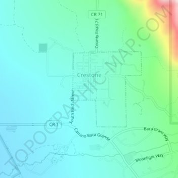
Name: Crestone topographic map, elevation, terrain.
Location: Crestone, Saguache County, Colorado, United States (37.98753 -105.70240 37.99896 -105.68913)
Average elevation: 2,444 m
Minimum elevation: 2,357 m
Maximum elevation: 2,842 m
Make a donation
Gear up for your next adventure:
As an Amazon Associate, this site earns from qualifying purchases at no extra cost to you.
Other topographic maps
Click on a map to view its topography, its elevation and its terrain.
Crestone Peak
United States > Colorado > Saguache County
Generally climbs of Crestone Peak or Crestone Needle start from a base camp at South Colony Lakes, east of the peak, accessed from the Wet Mountain Valley on the northeast side of the range. This route involves nearly 6,000 ft (1,800 m) of elevation gain, and ascends to a large relatively flat area called "The…
Average elevation: 3,875 m
Make a donation
Gear up for your next adventure:
As an Amazon Associate, this site earns from qualifying purchases at no extra cost to you.
Make a donation
Gear up for your next adventure:
As an Amazon Associate, this site earns from qualifying purchases at no extra cost to you.