
Bruzolo topographic map
Interactive map
Click on the map to display elevation.
About this map
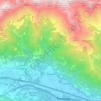
Name: Bruzolo topographic map, elevation, terrain.
Location: Bruzolo, Torino, Piemont, Italy (45.12292 7.18170 45.19538 7.21655)
Average elevation: 1,224 m
Minimum elevation: 397 m
Maximum elevation: 2,696 m
The town of Bruzolo is the main population centre of the commune and is its capoluogo. It stands to the left of the river Dora Riparia on an alluvial fan formed over the millennia by debris deposited by the Pissaglio and other minor torrents. The municipal territory also includes farmland and factories on the flood-plain of the Dora Riparia, and extends over the forested southern slopes of Punta Lunella, elevation 2,772 metres (9,094 ft), where there is a scattering of hamlets: Campobenedetto, Meisonardi, Comba, Bigiardi, Lunera, Coletto, Chiotetti, Seinera and Combette.