
Thank you for supporting this site ❤️
Make a donation
Make a donation
Gear up for your next adventure:
As an Amazon Associate, this site earns from qualifying purchases at no extra cost to you.
Sundridge topographic map
Click on the map to display elevation.
Thank you for supporting this site ❤️
Make a donation
Make a donation
Gear up for your next adventure:
As an Amazon Associate, this site earns from qualifying purchases at no extra cost to you.
About this map
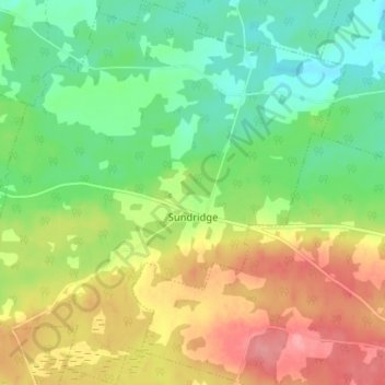
Name: Sundridge topographic map, elevation, terrain.
Average elevation: 46 m
Minimum elevation: 7 m
Maximum elevation: 97 m
Thank you for supporting this site ❤️
Make a donation
Make a donation
Gear up for your next adventure:
As an Amazon Associate, this site earns from qualifying purchases at no extra cost to you.
Other topographic maps
Click on a map to view its topography, its elevation and its terrain.
Lansdowne Lake
Canada > Nova Scotia > Municipality of Pictou County > New Lairg
Average elevation: 160 m
MacKays Corner
Canada > Nova Scotia > Municipality of Pictou County > Caribou River
Average elevation: 10 m