Geolocate

Sandon topographic map

Click on the map to display elevation.

About this map

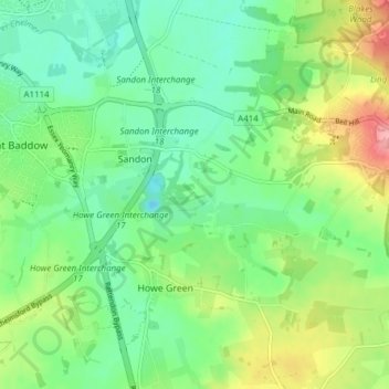
Name: Sandon topographic map, elevation, terrain.

Location: Sandon, Chelmsford, Essex, England, United Kingdom (51.68592 0.51320 51.73321 0.56191)

Average elevation: 41 m

Minimum elevation: 6 m

Maximum elevation: 111 m

Gear up for your next adventure:

🚴Cycling Backpacks - Backpacks for cyclists
🍳Camping Cookware - Cookware sets for outdoor meals
🎧Bluetooth Outdoor Earbuds - Listen to navigation cues or podcasts during long solo treks
🧥Down Jackets - Insulated jackets for cold weather
🥤Hydration Packs - Hydration systems for hiking

As an Amazon Associate, this site earns from qualifying purchases at no extra cost to you.