
Make a donation
Gear up for your next adventure:
As an Amazon Associate, this site earns from qualifying purchases at no extra cost to you.
Oturehua topographic map
Click on the map to display elevation.
Make a donation
Gear up for your next adventure:
As an Amazon Associate, this site earns from qualifying purchases at no extra cost to you.
About this map
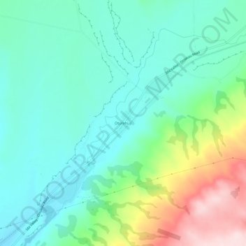
Name: Oturehua topographic map, elevation, terrain.
Location: Oturehua, Central Otago District, New Zealand (-45.02699 169.89302 -44.98699 169.93302)
Average elevation: 569 m
Minimum elevation: 476 m
Maximum elevation: 814 m
Make a donation
Gear up for your next adventure:
As an Amazon Associate, this site earns from qualifying purchases at no extra cost to you.
Other topographic maps
Click on a map to view its topography, its elevation and its terrain.
Dunstan Mountains
New Zealand > Central Otago District
The Dunstan Mountains are bisected by the 4-wheel drive Thomson Gorge Road which follows Thomsons Creek, incised into the eastern flank of the range and the Rise and Shine Creek on the western flank. Thomsons Saddle, between the two creeks, climbs to 980 m (3,220 ft) elevation.
Average elevation: 707 m