
Make a donation
Gear up for your next adventure:
As an Amazon Associate, this site earns from qualifying purchases at no extra cost to you.
Cochamó topographic map
Click on the map to display elevation.
Make a donation
Gear up for your next adventure:
As an Amazon Associate, this site earns from qualifying purchases at no extra cost to you.
About this map
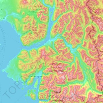
Name: Cochamó topographic map, elevation, terrain.
Location: Cochamó, Provincia de Llanquihue, Los Lagos Region, Chile (-42.19052 -72.64855 -41.31484 -71.72535)
Average elevation: 688 m
Minimum elevation: -1 m
Maximum elevation: 2,420 m
Make a donation
Gear up for your next adventure:
As an Amazon Associate, this site earns from qualifying purchases at no extra cost to you.
Other topographic maps
Click on a map to view its topography, its elevation and its terrain.
Cerro El Monstruo
Chile > Los Lagos Region > Provincia de Llanquihue > Cochamó
Average elevation: 1,296 m
Tronador
Chile > Los Lagos Region > Provincia de Llanquihue > Puerto Varas
Tronador (Spanish: Cerro Tronador) is an extinct stratovolcano in the southern Andes, located along the border between Argentina and Chile, near the Argentine city of Bariloche. The mountain was named Tronador (Spanish for "Thunderer") by locals in reference to the sound of falling seracs. With an altitude of…
Average elevation: 2,836 m
Make a donation
Gear up for your next adventure:
As an Amazon Associate, this site earns from qualifying purchases at no extra cost to you.
Osorno Volcano
Chile > Los Lagos Region > Provincia de Llanquihue > Puerto Varas
The basalt and andesite lava flows generated during these eruptions reached both Lago Llanquihue and Lago Todos Los Santos. All of the upper slopes of Osorno were, until recently, almost entirely covered in glacial ice. However, large areas of glacial retreat have now occurred on the N and W slopes of the…
Average elevation: 1,994 m
Villa Federico Werner
Chile > Los Lagos Region > Provincia de Llanquihue > Llanquihue > Villa Federico Werner
Average elevation: 88 m
Los Molinos
Chile > Los Lagos Region > Provincia de Llanquihue > Calbuco > Texas > Los Molinos
Average elevation: 20 m