
Make a donation
Gear up for your next adventure:
As an Amazon Associate, this site earns from qualifying purchases at no extra cost to you.
Bettenhausen topographic map
Click on the map to display elevation.
Make a donation
Gear up for your next adventure:
As an Amazon Associate, this site earns from qualifying purchases at no extra cost to you.
About this map
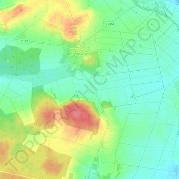
Name: Bettenhausen topographic map, elevation, terrain.
Location: Bettenhausen, Lich, Landkreis Gießen, Hessen, Deutschland (50.45673 8.80390 50.48847 8.85931)
Average elevation: 180 m
Minimum elevation: 151 m
Maximum elevation: 228 m
Make a donation
Gear up for your next adventure:
As an Amazon Associate, this site earns from qualifying purchases at no extra cost to you.
Other topographic maps
Click on a map to view its topography, its elevation and its terrain.
Nieder-Bessingen
Deutschland > Hessen > Landkreis Gießen > Lich
Nieder-Bessingen ist ein Stadtteil der fünf Kilometer südwestlich liegenden Kernstadt Lich im mittelhessischen Landkreis Gießen. Zum Dorf gehören die Wochenendsiedlung Albertshöhe sowie die außerhalb liegende Pein-Mühle, das Hofgut Mühlsachsen und die Wüstung Hausen. Das am Dorf vorbeifließende…
Average elevation: 195 m