
Make a donation
Gear up for your next adventure:
As an Amazon Associate, this site earns from qualifying purchases at no extra cost to you.
Bainbridge Island topographic map
Click on the map to display elevation.
Make a donation
Gear up for your next adventure:
As an Amazon Associate, this site earns from qualifying purchases at no extra cost to you.
Bainbridge Island
Bainbridge Island is characterized by diverse topography shaped by glacial activity during the last Ice Age. The island features gently rolling hills interspersed with flat lowlands and steep coastal bluffs. Elevations range from sea level along the shoreline to about 425 feet at its highest points, with terrain marked by deposits from the Vashon Glaciation, including glacial till and outwash plains. Numerous small valleys and ravines, carved by streams and erosion, crisscross the landscape. The coastline is varied, with rocky promontories, sandy beaches, and tidal inlets, adding to the island’s intricate terrain and natural beauty.
Make a donation
Gear up for your next adventure:
As an Amazon Associate, this site earns from qualifying purchases at no extra cost to you.
About this map
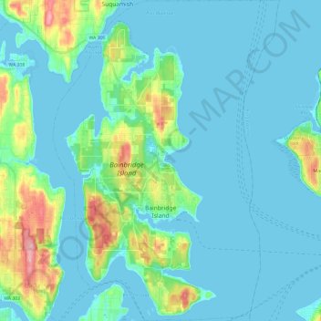
Name: Bainbridge Island topographic map, elevation, terrain.
Average elevation: 24 m
Minimum elevation: -5 m
Maximum elevation: 151 m
Make a donation
Gear up for your next adventure:
As an Amazon Associate, this site earns from qualifying purchases at no extra cost to you.
Other topographic maps
Click on a map to view its topography, its elevation and its terrain.
Seattle viewpoint
United States > Washington > Kitsap County > Bainbridge Island
Average elevation: 20 m
Make a donation
Gear up for your next adventure:
As an Amazon Associate, this site earns from qualifying purchases at no extra cost to you.
Make a donation
Gear up for your next adventure:
As an Amazon Associate, this site earns from qualifying purchases at no extra cost to you.
Make a donation
Gear up for your next adventure:
As an Amazon Associate, this site earns from qualifying purchases at no extra cost to you.
Make a donation
Gear up for your next adventure:
As an Amazon Associate, this site earns from qualifying purchases at no extra cost to you.
Make a donation
Gear up for your next adventure:
As an Amazon Associate, this site earns from qualifying purchases at no extra cost to you.