
Norte de Santander topographic map
Interactive map
Click on the map to display elevation.
About this map
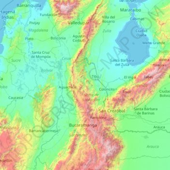
Name: Norte de Santander topographic map, elevation, terrain.
Location: Norte de Santander, Colombia (5.88179 -75.60925 11.00179 -70.48925)
Average elevation: 637 m
Minimum elevation: -4 m
Maximum elevation: 5,479 m
Other topographic maps
Click on a map to view its topography, its elevation and its terrain.
Villa del Rosario
Villa del Rosario, Oriental, Norte de Santander, RAP Gran Santander, 541030, Colombia
Average elevation: 841 m
vegetación
Colombia > Norte de Santander > Villa del Rosario
vegetación, vivienda, Villa del Rosario, Oriental, Norte de Santander, Colombia
Average elevation: 417 m