
Panay topographic map
Interactive map
Click on the map to display elevation.
Panay
Panay island is the sixth largest island in the Philippines by area, with a total land area of 12,011 km2 (4,637 sq mi). Mount Madja-as is the highest point in Panay with an elevation of 2,117 metres (6,946 ft) above sea level, located in town of Culasi in the northern province of Antique. Central Panay Mountain Range is the longest and largest mountain range in the island with a total length of 170 km (110 mi) north-south. Panay River is the longest river in the island with a total length of 169 km (105 mi) located in the province of Capiz.
About this map
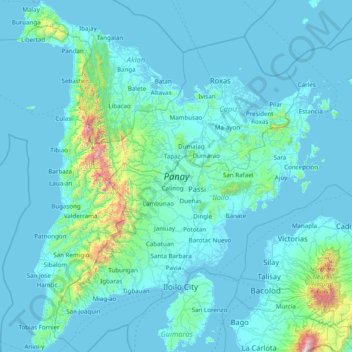
Name: Panay topographic map, elevation, terrain.
Location: Panay, Iloilo, Western Visayas, Philippines (10.40613 121.84313 11.93917 123.16535)
Average elevation: 117 m
Minimum elevation: -2 m
Maximum elevation: 2,319 m
Other topographic maps
Click on a map to view its topography, its elevation and its terrain.