
Make a donation
Gear up for your next adventure:
As an Amazon Associate, this site earns from qualifying purchases at no extra cost to you.
Sorriso topographic map
Click on the map to display elevation.
Make a donation
Gear up for your next adventure:
As an Amazon Associate, this site earns from qualifying purchases at no extra cost to you.
Sorriso
Sorriso é um município brasileiro do estado de Mato Grosso. É reconhecido como a Capital Nacional do Agronegócio e o maior produtor individual de soja do mundo. Segundo levantamento feito pelo IBGE, ocupa atualmente a terceira posição no ranking das maiores economias agrícolas do País. Pertence a microrregião de Alto Teles Pires e mesorregião do Norte Mato-grossense e sua população é estimada em 90.314 habitantes, conforme dados do IBGE de 2019. Está a uma altitude de 365 metros.
Make a donation
Gear up for your next adventure:
As an Amazon Associate, this site earns from qualifying purchases at no extra cost to you.
About this map
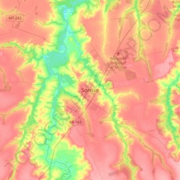
Name: Sorriso topographic map, elevation, terrain.
Average elevation: 367 m
Minimum elevation: 310 m
Maximum elevation: 406 m
Make a donation
Gear up for your next adventure:
As an Amazon Associate, this site earns from qualifying purchases at no extra cost to you.