
Big Sur topographic map
Interactive map
Click on the map to display elevation.
About this map
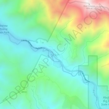
Name: Big Sur topographic map, elevation, terrain.
Location: Big Sur, Monterey County, California, United States (36.25024 -121.82745 36.29024 -121.78745)
Average elevation: 313 m
Minimum elevation: 20 m
Maximum elevation: 1,026 m
Other topographic maps
Click on a map to view its topography, its elevation and its terrain.
Pebble Beach
United States > California > Monterey County > Del Monte Forest
Pebble Beach, Del Monte Forest, Monterey County, California, 93953, United States
Average elevation: 53 m
Bradley
United States > California > Monterey County
Bradley, Monterey County, California, United States
Average elevation: 190 m
Salinas
United States > California > Monterey County > Salinas
Salinas, Monterey County, California, United States
Average elevation: 19 m