
Carterton District topographic map
Interactive map
Click on the map to display elevation.
About this map
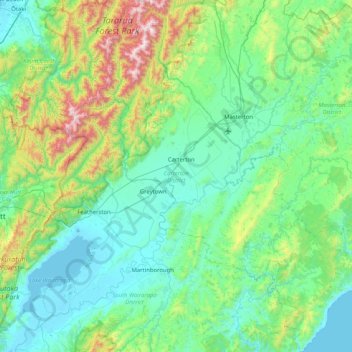
Name: Carterton District topographic map, elevation, terrain.
Location: Carterton District, Wellington, New Zealand (-41.36245 175.27018 -40.74514 175.99292)
Average elevation: 280 m
Minimum elevation: -2 m
Maximum elevation: 1,522 m
Other topographic maps
Click on a map to view its topography, its elevation and its terrain.
Wellington
New Zealand > Wellington > Wellington City
Averaging 2,055 hours of sunshine per year, the climate of Wellington is temperate marine, (Köppen: Cfb), generally moderate all year round with warm summers and mild winters, and rarely sees temperatures above 23 °C (73 °F) or below 4 °C (39 °F). The hottest recorded temperature in the city is 31.1 °C…
Average elevation: 85 m
Wellington
New Zealand > Wellington > Wellington City
Averaging 2,055 hours of sunshine per year, the climate of Wellington is temperate marine, (Köppen: Cfb, Trewartha: Cflk), generally moderate all year round with warm summers and cool to mild winters, and rarely sees temperatures above 26 °C (79 °F) or below 4 °C (39 °F). The hottest recorded temperature…
Average elevation: 85 m
Greytown
New Zealand > Wellington > South Wairarapa District > Greytown Community
Average elevation: 59 m
Featherston
New Zealand > Wellington > South Wairarapa District > Featherston Community
Average elevation: 125 m
Lake Ferry
New Zealand > Wellington > South Wairarapa District > Martinborough Community
Average elevation: 16 m
South Featherston
New Zealand > Wellington > South Wairarapa District > Featherston Community > Featherston
Average elevation: 26 m
Start
New Zealand > Wellington > South Wairarapa District > Martinborough Community
Average elevation: 255 m
Wellington
New Zealand > Wellington > Wellington City
Averaging 2,055 hours of sunshine per year, the climate of Wellington is temperate marine, (Köppen: Cfb, Trewartha: Cflk), generally moderate all year round with mild summers and cool to mild winters, and rarely sees temperatures above 26 °C (79 °F) or below 4 °C (39 °F). The hottest recorded temperature…
Average elevation: 85 m
Glendhu
New Zealand > Wellington > South Wairarapa District > Martinborough Community
Average elevation: 87 m
Lake Ōnoke
New Zealand > Wellington > South Wairarapa District > Featherston Community
Average elevation: 2 m
Wellington
New Zealand > Wellington > Wellington City
Averaging 2,055 hours of sunshine per year, the climate of Wellington is temperate marine, (Köppen: Cfb), generally moderate all year round with warm summers and mild winters, and rarely sees temperatures above 26 °C (79 °F) or below 4 °C (39 °F). The hottest recorded temperature in the city is 31.1 °C…
Average elevation: 85 m
Wellington
New Zealand > Wellington > Wellington City
Averaging 2,055 hours of sunshine per year, the climate of Wellington is temperate marine, (Köppen: Cfb), generally moderate all year round with warm summers and mild winters, and rarely sees temperatures above 23 °C (73 °F) or below 4 °C (39 °F). The hottest recorded temperature in the city is 31.1 °C…
Average elevation: 85 m
Wellington
New Zealand > Wellington > Wellington City
Averaging 2,055 hours of sunshine per year, the climate of Wellington is temperate marine, (Köppen: Cfb), generally moderate all year round with warm summers and mild winters, and rarely sees temperatures above 30 °C (86 °F) or below 4 °C (39 °F). The hottest recorded temperature in the city is 31.1 °C…
Average elevation: 85 m
Riversdale Beach
New Zealand > Wellington > Masterton District > Riversdale Beach
Average elevation: 20 m