
Central Transdanubia topographic map
Interactive map
Click on the map to display elevation.
About this map
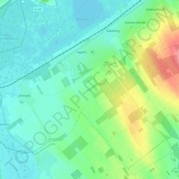
Name: Central Transdanubia topographic map, elevation, terrain.
Location: Central Transdanubia, Transdanubia, 2484, Hungary (47.13691 18.55494 47.21485 18.67494)
Average elevation: 122 m
Minimum elevation: 100 m
Maximum elevation: 182 m
Other topographic maps
Click on a map to view its topography, its elevation and its terrain.