Geolocate

Lerma topographic map

Click on the map to display elevation.

About this map

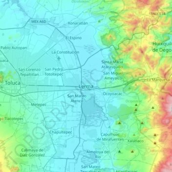
Name: Lerma topographic map, elevation, terrain.

Location: Lerma, State of Mexico, 52006, Mexico (19.12603 -99.67211 19.44603 -99.35211)

Average elevation: 2,752 m

Minimum elevation: 2,558 m

Maximum elevation: 3,843 m

Gear up for your next adventure:

🥾Hiking Shoes - Lightweight hiking shoes for day hikes
📡Satellite Messengers - Emergency communication devices
🚴Bike GPS - GPS devices for cycling
Survival Blankets - Emergency thermal blankets
🎒Tactical Waist Packs - Quick access to your compass, phone, and snacks while walking

As an Amazon Associate, this site earns from qualifying purchases at no extra cost to you.