
Town of Sandy Creek topographic map
Interactive map
Click on the map to display elevation.
About this map
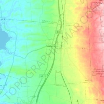
Name: Town of Sandy Creek topographic map, elevation, terrain.
Location: Town of Sandy Creek, Oswego County, New York, United States (43.59221 -76.19990 43.68054 -76.01661)
Average elevation: 161 m
Minimum elevation: 73 m
Maximum elevation: 344 m
Other topographic maps
Click on a map to view its topography, its elevation and its terrain.
Dutch Settlement
United States > New York > Oswego County > Town of West Monroe
Dutch Settlement, Town of West Monroe, Oswego County, New York, 13167, United States
Average elevation: 148 m
Town of Granby
United States > New York > Oswego County
Town of Granby, Oswego County, New York, 13115, United States
Average elevation: 125 m