
Make a donation
Gear up for your next adventure:
As an Amazon Associate, this site earns from qualifying purchases at no extra cost to you.
Rochester topographic map
Click on the map to display elevation.
Make a donation
Gear up for your next adventure:
As an Amazon Associate, this site earns from qualifying purchases at no extra cost to you.
About this map
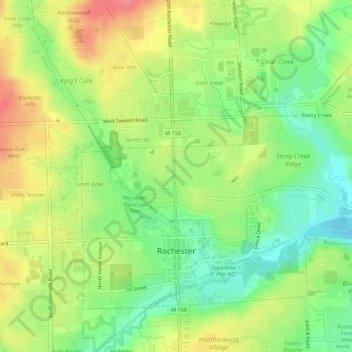
Name: Rochester topographic map, elevation, terrain.
Location: Rochester, Oakland County, Michigan, United States (42.67394 -83.14860 42.70440 -83.09382)
Average elevation: 242 m
Minimum elevation: 208 m
Maximum elevation: 281 m
Make a donation
Gear up for your next adventure:
As an Amazon Associate, this site earns from qualifying purchases at no extra cost to you.
Other topographic maps
Click on a map to view its topography, its elevation and its terrain.
Oakley Park
United States > Michigan > Oakland County > Commerce Charter Township
Average elevation: 282 m
Make a donation
Gear up for your next adventure:
As an Amazon Associate, this site earns from qualifying purchases at no extra cost to you.