Geolocate
👉 Easily get elevation data in JSON, GeoTIFF and KML formats using Elevation API
Thank you for supporting this site ❤️
Make a donation

Gear up for your next adventure:

As an Amazon Associate, this site earns from qualifying purchases at no extra cost to you.

Angat topographic map

Click on the map to display elevation.

About this map

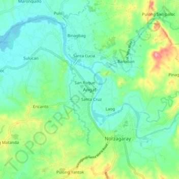
Name: Angat topographic map, elevation, terrain.

Location: Angat, Bulacan, Central Luzon, 3012, Philippines (14.88779 120.98914 14.96779 121.06914)

Average elevation: 53 m

Minimum elevation: 17 m

Maximum elevation: 144 m

Other topographic maps

Click on a map to view its topography, its elevation and its terrain.

Baliwag

Philippines > Bulacan

Average elevation: 16 m

Gear up for your next adventure:

📡Portable Emergency Radios - Stay informed about weather warnings and bushfire alerts
🔋Solar Power Banks - Solar chargers for outdoors
🍳Ultralight Camping Stoves - Boil water quickly for meals using minimal fuel
🧥Softshell Jackets - Flexible outdoor jackets
🧥Packable Rain Jackets - Breathable waterproof layers for unpredictable mountain weather

As an Amazon Associate, this site earns from qualifying purchases at no extra cost to you.