
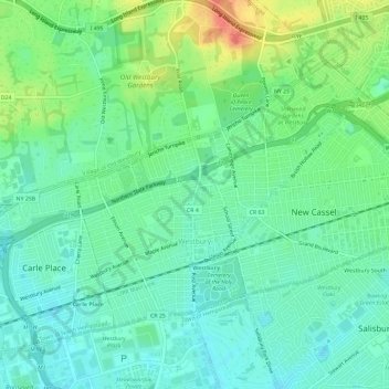
Village of Westbury topographic map
Interactive map
Click on the map to display elevation.
About this map
Name: Village of Westbury topographic map, elevation, terrain.
Average elevation: 39 m
Minimum elevation: 24 m
Maximum elevation: 71 m
Other topographic maps
Click on a map to view its topography, its elevation and its terrain.
Village of Lattingtown
États-Unis d'Amérique > New York > Nassau County
Village of Lattingtown, Town of Oyster Bay, Nassau County, New York, 11560, États-Unis d'Amérique
Average elevation: 20 m
Village of Kings Point
États-Unis d'Amérique > New York > Nassau County
Village of Kings Point, Town of North Hempstead, Nassau County, New York, 11024, États-Unis d'Amérique
Average elevation: 9 m
Village of Island Park
États-Unis d'Amérique > New York > Nassau County
Village of Island Park, Town of Hempstead, Nassau County, New York, 11558, États-Unis d'Amérique
Average elevation: 1 m
Village of Lynbrook
États-Unis d'Amérique > New York > Nassau County
Village of Lynbrook, Town of Hempstead, Nassau County, New York, 11563, États-Unis d'Amérique
Average elevation: 8 m
Village of Mineola
États-Unis d'Amérique > New York > Nassau County
Village of Mineola, Town of North Hempstead, Nassau County, New York, 11501, États-Unis d'Amérique
Average elevation: 35 m
Glen Head
États-Unis d'Amérique > New York > Nassau County
Glen Head, Town of Oyster Bay, Nassau County, New York, États-Unis d'Amérique
Average elevation: 40 m
Village of Rockville Centre
États-Unis d'Amérique > New York > Nassau County
Village of Rockville Centre, Town of Hempstead, Nassau County, New York, 11570, États-Unis d'Amérique
Average elevation: 11 m