
Penampang topographic map
Click on the map to display elevation.
About this map
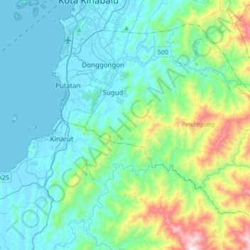
Name: Penampang topographic map, elevation, terrain.
Location: Penampang, West Coast Division, Sabah, Malaysia (5.72722 116.05686 5.95147 116.33436)
Average elevation: 253 m
Minimum elevation: -1 m
Maximum elevation: 1,398 m
Other topographic maps
Click on a map to view its topography, its elevation and its terrain.
Gaya Island
Malaysia > Sabah > Kota Kinabalu
Gaya Island (Malay: Pulau Gaya) is a sizeable Malaysian island of 1,465 ha, just 10 minutes off Kota Kinabalu, Sabah and forms part of the Tunku Abdul Rahman National Park. Gaya Island derived its name from the Bajau word "Gayo" which means big and occupies an area of 15 km² (3,700 acres) with an elevation of…
Average elevation: 34 m
Tambunan
Tambunan (Malay: Pekan Tambunan) is the capital of the Tambunan District in the Interior Division of Sabah, Malaysia. Its population was estimated to be around 35,667 in 2010. It is located 80 kilometres east of the state capital, Kota Kinabalu (to which is connected by the Kota Kinabalu-Tambunan-Keningau…
Average elevation: 697 m