
Make a donation
Gear up for your next adventure:
As an Amazon Associate, this site earns from qualifying purchases at no extra cost to you.
Treborough topographic map
Click on the map to display elevation.
Make a donation
Gear up for your next adventure:
As an Amazon Associate, this site earns from qualifying purchases at no extra cost to you.
About this map
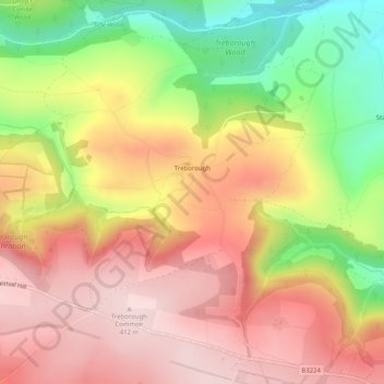
Name: Treborough topographic map, elevation, terrain.
Average elevation: 276 m
Minimum elevation: 88 m
Maximum elevation: 412 m
Make a donation
Gear up for your next adventure:
As an Amazon Associate, this site earns from qualifying purchases at no extra cost to you.
Other topographic maps
Click on a map to view its topography, its elevation and its terrain.
Leighland Chapel
United Kingdom > England > Somerset > Somerset West and Taunton > Old Cleeve
Average elevation: 226 m
Pleamore Cross
United Kingdom > England > Somerset > Somerset West and Taunton > Rockwell Green > Pleamore Cross
Average elevation: 125 m
Luccombe
United Kingdom > England > Somerset > Somerset West and Taunton > Luccombe
Average elevation: 157 m
Make a donation
Gear up for your next adventure:
As an Amazon Associate, this site earns from qualifying purchases at no extra cost to you.
Hillfarrance
United Kingdom > England > Somerset > Somerset West and Taunton > Hillfarrance
Average elevation: 41 m
Nailsbourne
United Kingdom > England > Somerset > Somerset West and Taunton > Kingston St. Mary > Nailsbourne
Average elevation: 66 m