Geolocate

Pokuru topographic map

Click on the map to display elevation.

About this map

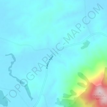
Name: Pokuru topographic map, elevation, terrain.

Location: Pokuru, Waipa District, Waikato, New Zealand (-38.06611 175.22498 -38.04611 175.24498)

Average elevation: 80 m

Minimum elevation: 27 m

Maximum elevation: 440 m

Other topographic maps

Click on a map to view its topography, its elevation and its terrain.

Waipa District

New Zealand > Waikato > Waipa District

Average elevation: 117 m

Gear up for your next adventure:

🩹Wilderness First Aid Kits - Comprehensive medical kits tailored for hiking and remote exploration
🥾Heavy Duty Hiking Boots - Ankle-supporting boots for carrying heavy packs on steep contours
🩹First Aid Kits - Emergency kits for hiking
🧥Packable Rain Jackets - Breathable waterproof layers for unpredictable mountain weather
📕Hiking Guide Books - Guides for hiking trails

As an Amazon Associate, this site earns from qualifying purchases at no extra cost to you.