
Make a donation
Gear up for your next adventure:
As an Amazon Associate, this site earns from qualifying purchases at no extra cost to you.
Ware topographic map
Click on the map to display elevation.
Make a donation
Gear up for your next adventure:
As an Amazon Associate, this site earns from qualifying purchases at no extra cost to you.
About this map
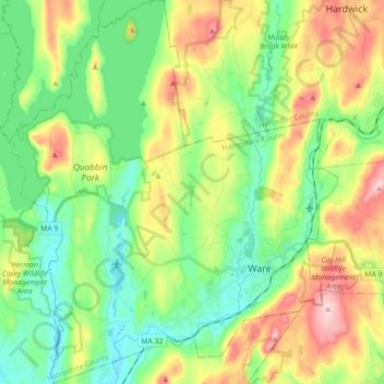
Name: Ware topographic map, elevation, terrain.
Location: Ware, Hampshire County, Massachusetts, 01082, United States (42.22016 -72.35602 42.35211 -72.20328)
Average elevation: 198 m
Minimum elevation: 108 m
Maximum elevation: 361 m
Make a donation
Gear up for your next adventure:
As an Amazon Associate, this site earns from qualifying purchases at no extra cost to you.
Other topographic maps
Click on a map to view its topography, its elevation and its terrain.
South Hadley Falls
United States > Massachusetts > Hampshire County > South Hadley
Average elevation: 50 m
Make a donation
Gear up for your next adventure:
As an Amazon Associate, this site earns from qualifying purchases at no extra cost to you.
Make a donation
Gear up for your next adventure:
As an Amazon Associate, this site earns from qualifying purchases at no extra cost to you.
Mill River Recreation Area
United States > Massachusetts > Hampshire County > Amherst > North Amherst
Average elevation: 66 m
Make a donation
Gear up for your next adventure:
As an Amazon Associate, this site earns from qualifying purchases at no extra cost to you.
Wildwood Conservation Area
United States > Massachusetts > Hampshire County > Amherst
Average elevation: 89 m
Worthington Corners
United States > Massachusetts > Hampshire County > Worthington
Average elevation: 450 m
Make a donation
Gear up for your next adventure:
As an Amazon Associate, this site earns from qualifying purchases at no extra cost to you.
Make a donation
Gear up for your next adventure:
As an Amazon Associate, this site earns from qualifying purchases at no extra cost to you.