
Thank you for supporting this site ❤️
Make a donation
Make a donation
Gear up for your next adventure:
As an Amazon Associate, this site earns from qualifying purchases at no extra cost to you.
Knittelfeld topographic map
Click on the map to display elevation.
Thank you for supporting this site ❤️
Make a donation
Make a donation
Gear up for your next adventure:
As an Amazon Associate, this site earns from qualifying purchases at no extra cost to you.
About this map
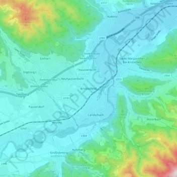
Name: Knittelfeld topographic map, elevation, terrain.
Location: Knittelfeld, Bezirk Murtal, Styria, 8720, Austria (47.17474 14.78972 47.25474 14.86972)
Average elevation: 741 m
Minimum elevation: 602 m
Maximum elevation: 1,441 m
Thank you for supporting this site ❤️
Make a donation
Make a donation
Gear up for your next adventure:
As an Amazon Associate, this site earns from qualifying purchases at no extra cost to you.